Rob presented our investigation into various organic carbon analysis protocols at the Manchester Museum. If you are interested in measuring the carbon content of a sediment, take a look at the Standard Operating Procedures page – protocols 007 and 008 give both accurate and precise results using an elemental analyser.
Author: Rob
Steart Vegetation Survey 2025
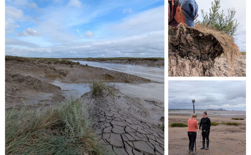
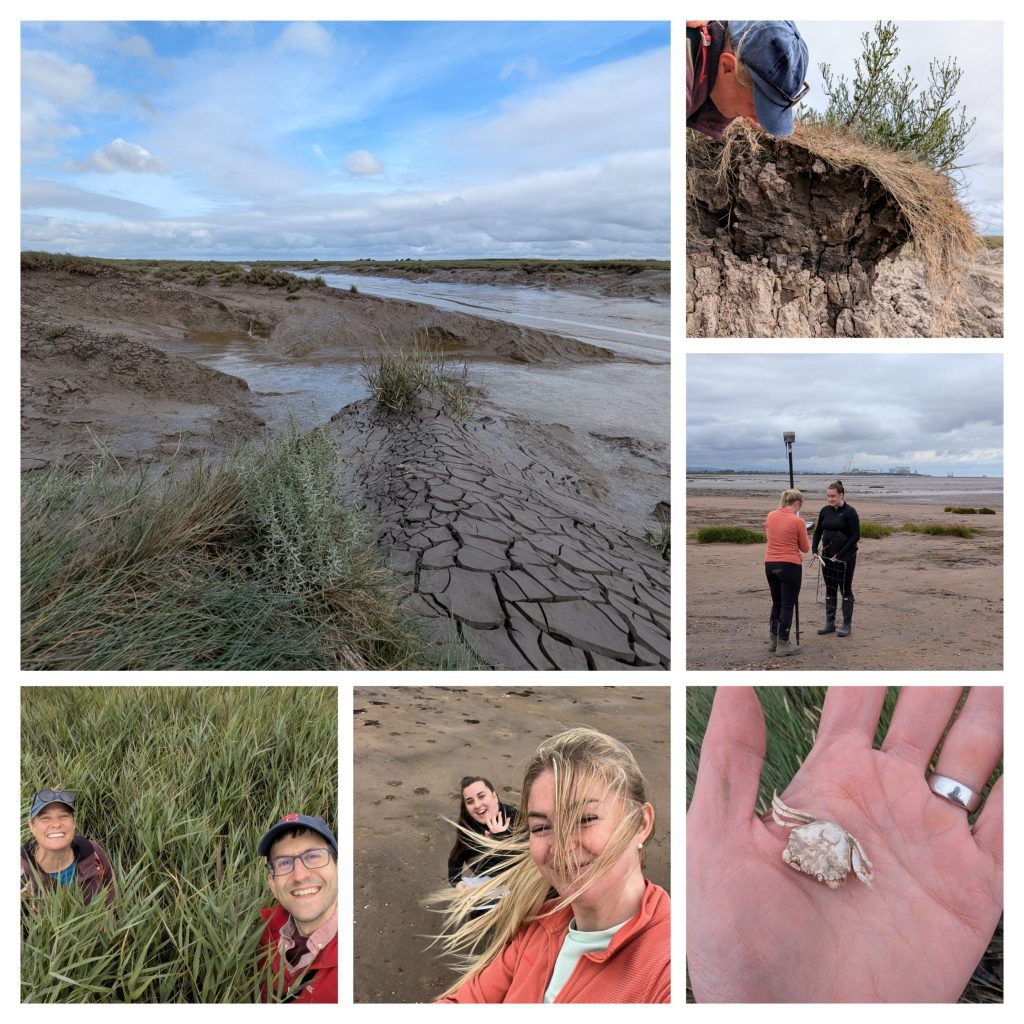
Members of the team visited WWT Steart Marshes, carrying out a vegetation census, geomorphology assessments, invertebrate surveys, and long-term landscape monitoring.
Allochthonous carbon primarily of marine origin in Irish saltmarshes: novel insights from bacteriohopanepolyol biomarkers
Saule Akhmetkaliyeva, Robert Sparkes, Eliza Fairchild, Ragna Hoogenboom, Grace Cott
Sustainable Microbiology, 2025
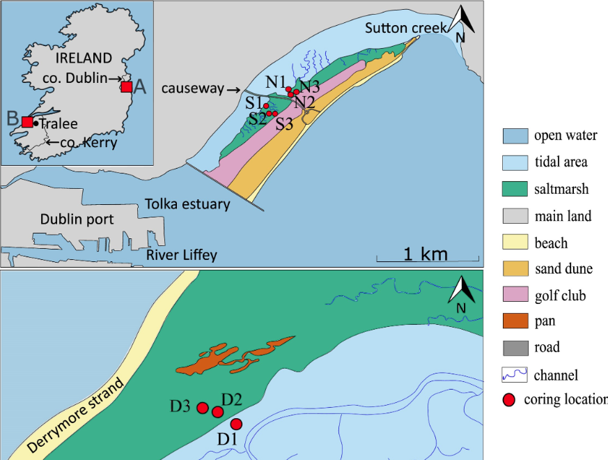
Coastal blue carbon ecosystems (BCEs) are among the most effective carbon (C) sinks, yet Irish saltmarshes, covering 4000–6500 hectares, remain understudied in terms of C sources. Understanding saltmarshes’ connectivity to marine and terrestrial sources, and the provenance of allochthonous (ex-situ-produced) carbon, is essential for assessing their long-term C sequestration potential and management. This study analysed organic carbon (OC) and bacteriohopanepolyol biomarkers (BHPs), microbial lipids that trace sedimentary OC sources, in sediment cores from Derrymore Island (DI) and North Bull Island (NBI). OC concentrations varied down-core, ranging from 0.26–26.68 wt% at DI, 0.44–12.19 wt% in NBI’s North Lagoon, and 0.07–26.45 wt% in its South Lagoon. The Rsoil index values (0.02–0.24 at DI, 0.01–0.06 at NBI) indicate a predominantly marine OC origin, though soil-specific BHPs were present, with higher soil marker concentrations in deeper, older DI sediments. This suggests saltmarshes may gradually transition toward terrestrial characteristics over time. This study enhances our understanding of OC sequestration in two Irish saltmarshes, highlighting their dynamic nature. The allochthonous nature of sequestered sedimentary OC further underscores the importance of sustained tidal influence and connectivity with the wider marine environment. Further research into labile OC sources is recommended to enhance carbon assessments in these ecosystems.
Seascape connectivity: evidence, knowledge gaps and implications for temperate coastal ecosystem restoration practice and policy
Joanne Preston, Rachel Dunk and 28 co-authors
NPJ Ocean Sustainability, 2025
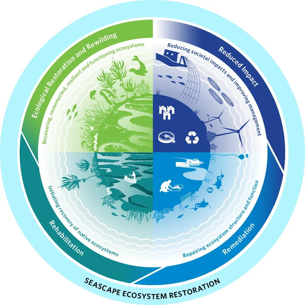
Temperate coastal marine ecosystems have undergone severe global loss and degradation. We provide a framework for considering ecological connectivity in marine systems and evidence for ecological connectivity across temperate coastal seascapes, developed through expert consensus and structured review. We demonstrate that ecosystem functioning and the delivery of ecosystem services require the existence of a healthy mosaic of coastal habitats, maintained by the exchanges of matter and energy between them. We advocate a seascape approach, that restores connectivity and optimal structure-function relationships, is crucial for successful ecosystem restoration. Consequently, we provide recommendations to deliver seascape restoration of coastal habitats to support the targets set by the 2021-30 UN Decades of Ocean Science and Ecosystem Restoration. Acknowledging the interconnected nature of coastal ecosystems has implications for policy. We identify opportunities and actions to support nature recovery and integrate policy frameworks across climate and biodiversity agendas to achieve international goals for planetary resilience.
World Saltmarsh Day 2025
We are proud to have contributed to the WWF’s “State of the World’s Saltmarshes” report, which was released on 11th June, World Saltmarsh Day.

Our research has shown that a single restored saltmarsh in the UK can store as much carbon over four years as more than one million newly planted trees can capture in a decade.
Saltmarshes are coastal wetlands shaped by the tides. These dynamic habitats create a unique watery mosaic of salt-tolerant plants and shrubs, interwoven with a network of creeks and pools.
Today, Wednesday 11th June 2025, marks the first ever World Saltmarsh Day. Led by our partners, WWT, we are raising awareness of the superpowers of these coastal wetlands.
Saltmarshes play an important role in climate change mitigation and are capable of capturing and storing more carbon than the same sized area of forests on land. These valuable habitats can absorb the energy of the tides – protecting coastlines and manmade sea defences behind them – and provide a haven for wildlife. Saltmarshes are also a beautiful place to relax and lose yourself in the sights and sounds of nature.
Dr Lucy McMahon, Research Fellow in Coastal Ecology at Manchester Met, said: “Despite the amazing benefits they provide, saltmarshes are largely unknown among the public – many people struggle to even recognise what saltmarsh is”.
Dr Robert Sparkes, Senior Lecturer in Environmental Science added: “We have lost around 50% of saltmarshes in the UK to urban and agricultural developments. We hope World Saltmarsh Day will raise global awareness of these special but underappreciated habitats and inspire action which promotes their restoration and conservation”.
Find out how, in the fight against climate change, our research has revealed the importance of forgotten natural resources: https://www.mmu.ac.uk/news-and-events/news/story/letting-nature-back
Invited perspectives: Managed realignment as a solution to mitigate coastal flood risks – optimizing success through knowledge co-production
Mark Schuerch, Hannah Mossman, Harriet Moore, Elizabeth Christie, and Joshua Kiesel
Natural Hazards and Earth System Sciences, 2022
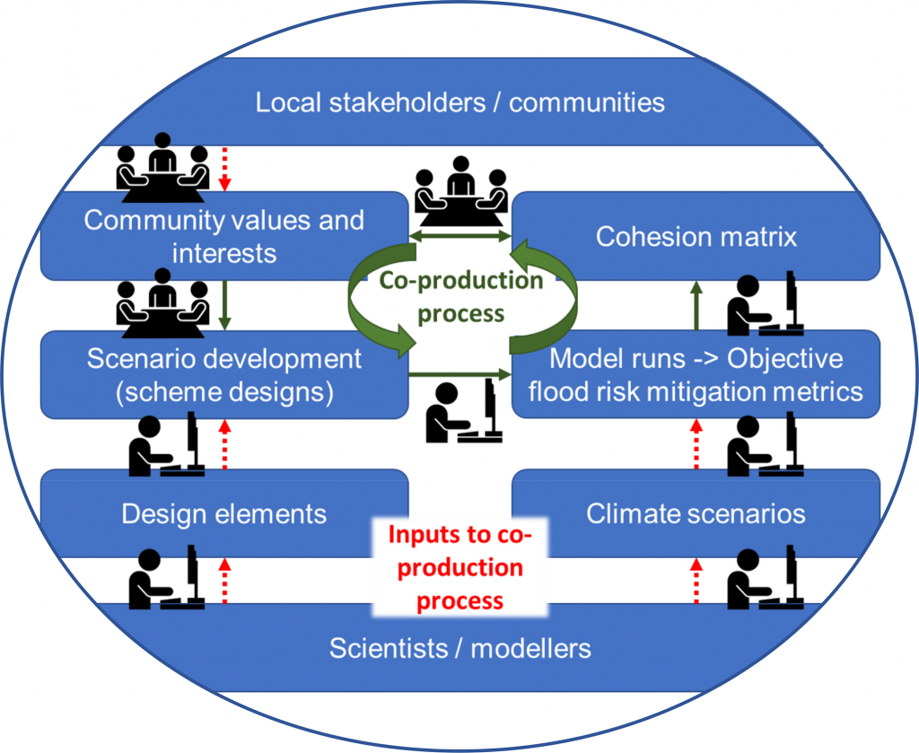
Nature-based solutions are increasingly suggested for mitigating coastal flood risks in the face of climate change. Managed realignment (MR), a coastal adaptation strategy that entails the landward realignment of coastal defences to restore coastal habitats (often salt marshes), plays a pivotal role in implementing nature-based solutions in the coastal zone. Across Europe, more than 130 sites have been implemented so far, often to harness their potential to mitigate coastal flood risks while restoring coastal habitats (ABPmer, 2021). However, local communities often oppose MR projects, not only because they are seen as returning hard-won land to the sea but also because their coastal protection function is less trusted than traditional hard engineering techniques. This scepticism has foundation. The proclaimed coastal protection function of MRs is based on a broad body of literature on the protective function of natural salt marshes. However, contrary to natural salt marshes, MRs are often semi-enclosed tidal basins with narrow breaches to the open sea/estuary. Recent studies indicate that MR-internal hydrodynamics may significantly reduce their coastal protection, depending on their engineering design. To successfully implement MR, a much-improved scientific knowledge base is needed, as well as a process for addressing community concerns and genuinely engaging stakeholders in decision-making beyond the usual obligatory consultancy approach. Here, we propose the co-production of scientific knowledge with local communities and stakeholders to optimize the success of coastal nature-based solutions and promote community acceptance.
Restored saltmarshes have low beta diversity due to limited topographic variation, but this can be countered by management
Peter Lawrence, Martin Sullivan, Hannah Mossman
Journal of Applied Ecology, 2022
- Spatial heterogeneity of species (beta diversity) is an important attribute of ecological communities, but is less frequently considered when assessing restoration success than other aspects of diversity (gamma and alpha). Differences in beta diversity between restored and natural sites may arise due to differences in environmental heterogeneity.
- We used a nested sampling design to survey plant communities and environmental conditions (elevation, redox potential and metrics of topography) on four pairs of restored and natural saltmarshes. We assessed whether there were differences in both alpha and beta diversity between natural and restored sites and analysed their environmental drivers.
- Topography was an important driver of plant alpha diversity and beta diversity on saltmarshes. The effects of topography were partly indirect, mediated though changes in redox potential, but topography also influenced plant communities independently of both elevation and redox.
- Restored saltmarshes were less heterogeneous in topography than natural marshes. This reduced topography was reflected in lower beta diversity; plant communities 1 m apart in natural marshes were as dissimilar as those found 20 m apart in restored marshes.
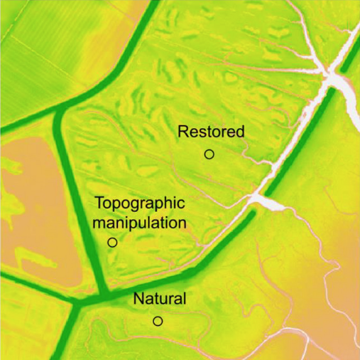
- Large-scale topographic manipulation carried out at one site a decade after initial restoration successfully increased topographic heterogeneity and increased beta diversity when surveyed 3 years after manipulation. These changes were still evident when resurveyed after a further 2 years.
- Synthesis and applications. Increasing environmental heterogeneity can improve restoration outcomes by increasing beta diversity on restored sites. The effect of environmental heterogeneity is likely to be particularly strong within intertidal habitats such as saltmarshes, where small changes in topography can determine whether a species can occur at a given location. Topographic manipulation is a feasible post-restoration technique that can be applied to ensure restored saltmarshes better meet policy targets of biological, physical and functional equivalence with natural marshes.
Manipulating saltmarsh microtopography modulates the effects of elevation on sediment redox potential and halophyte distribution
Hannah Mossman, Alastair Grant, Anthony Davy
Journal of Ecology, 2019
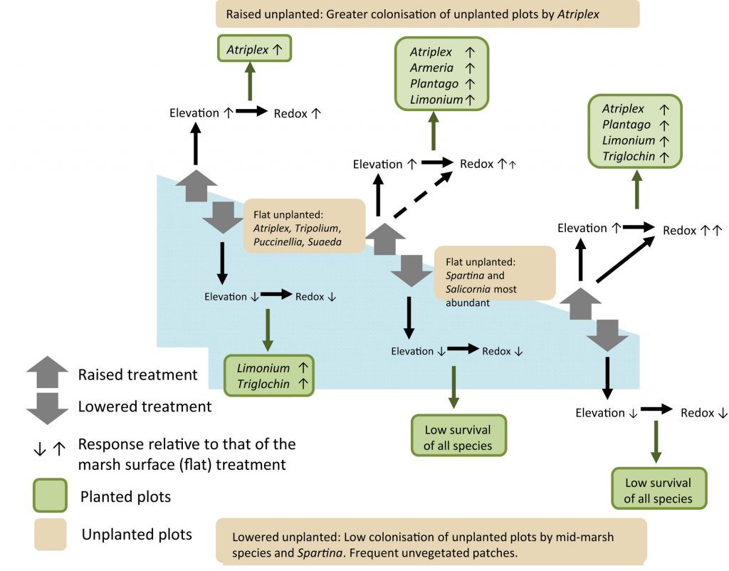
- Halophyte distributions on saltmarshes are strongly related to elevation in the tidal frame. However, collinearity between elevation, the consequent inundation regime, and sediment waterlogging/redox potential obscures the proximate causes of distribution patterns. We sought to distinguish the effects of elevation per se from those of waterlogging by manipulating microtopography.
- We experimentally manipulated elevation by ±15 cm at locations that spanned the elevation ranges of three saltmarshes recently reactivated by managed coastal realignment. Experimental plots were initially cleared of any vegetation. Elevation and sediment redox potential were determined for each plot. We planted five perennial species (Armeria maritima, Atriplex portulacoides, Limonium vulgare, Plantago maritima and Triglochin maritima) in half of the plots, recording survival over 4 years, and monitored natural colonization of the other plots.
- Overall, redox potential increased with elevation. Sediments were more oxidizing in raised plots and more reducing in lowered plots. Redox reductions in lowered plots were in line with those that would be predicted from the overall redox/elevation relationship, but increases in raised plots were greater than predicted from elevation alone.
- Plant colonization and survival was poorer in lowered plots and, for most species, improved in raised plots. This poorer colonization and survival can, in part, be attributed to the concomitant alterations in redox potential and elevation in the tidal frame, but microtopographic manipulation also had substantial independent effects on plant performance, including on the survival of all planted species and the colonization of Puccinellia maritima, Salicornia europaea agg. and Tripolium pannonicum.
- Synthesis. Microtopography can have effects on sediment chemistry and plant performance similar in magnitude to those of overall tidal elevation. Understanding how its effects modulate the relationship between tidal elevation, redox and other environmental conditions helps clarify the abiotic factors that fundamentally determine halophyte colonization and survival. These results support the use of topographic manipulation to enhance the diversity of created saltmarshes.
Restored saltmarshes lack the topographic diversity found in natural habitat
Peter Lawrence, Graham Smith, Martin Sullivan, Hannah Mossman
Ecological Engineering, 2018
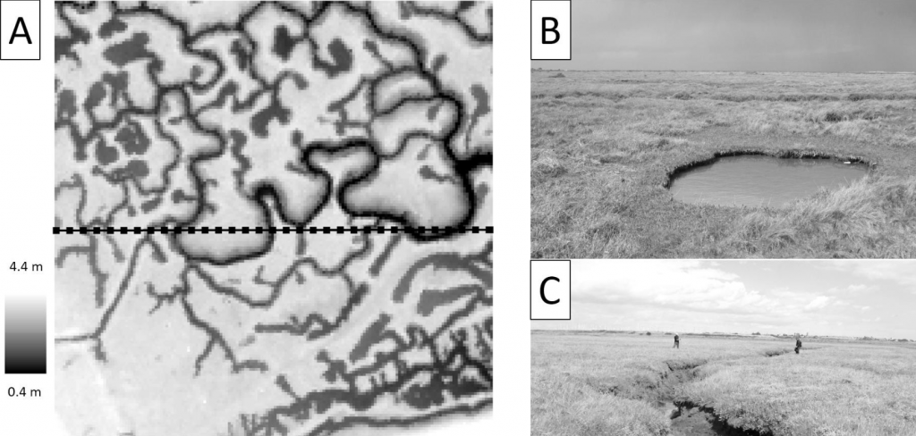
Saltmarshes can be created to compensate for lost habitat by a process known as managed realignment (MR), where sea defences are deliberately breached to flood low-lying agricultural land. However, the vegetation that develops on MR sites is not equivalent to natural habitat. In natural sites, surface topography and creek networks are drivers of vegetation diversity, but their development on restored sites has not been well studied. We investigate the topographic characteristics of 19 MR areas, and compare these to nearby natural saltmarshes (representing desired conditions) and to coastal agricultural landscapes (representing conditions prior to MR). From high-resolution LiDAR data, we extracted values of elevation, six measures of surface topography (although two were later excluded due to collinearity), and three measures of creek density. MR and natural marshes differed significantly in all surface topographic indices, with MR sites having lower rugosity and more concave features, with greater potential for water accumulation. MR sites also had significantly lower creek density. MRs and coastal agricultural landscapes were more similar, differing in only one topographic measure. Importantly, there was no relationship between age since restoration and any of the topographic variables, indicating that restored sites are not on a trajectory to become topographically similar to natural marshes. MR schemes need to consider actively constructing topographic heterogeneity; better mirroring natural sites in this way is likely to benefit the development of saltmarsh vegetation, and will also have implications for a range of ecosystem functions.
Does managed coastal realignment create saltmarshes with ‘equivalent biological characteristics’ to natural reference sites?
Hannah Mossman, Anthony Davy, Alastair Grant
Journal of Applied Ecology, 2012
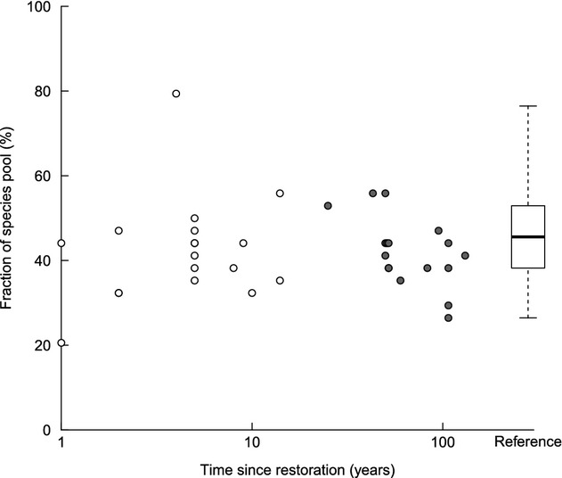
- Coastal saltmarshes provide distinctive biodiversity and important ecosystem services, including coastal defence, supporting fisheries and nutrient cycling. However, c. 50% of the world’s coastal marshes are degraded or have been lost, with losses continuing. In both Europe and North America, there is a legal requirement to create habitats to substitute for losses. How well do created habitats replicate natural salt marshes?
- We compared plant communities and environmental characteristics of 18 deliberately realigned (managed realignment, MR – between 1 and 14 years old), 17 accidentally realigned (AR, 25–131 years old) sites with those on 34 natural reference saltmarshes in the UK.
- Halophytic species colonized individual realignment sites rapidly, attaining species richness similar to nearby reference marshes after 1 year. Nevertheless, the community composition of MR sites was significantly different from reference sites, with early-successional species remaining dominant, even on the high marsh.
- The dominance of pioneer species on the low and mid-marsh may be because, at the same elevation, sediments were less oxygenated than on reference sites. Sediments were well oxygenated on the high marsh, but were often drier than on natural marshes.
- Overall community composition of AR marshes was not significantly different to reference marshes, but the characteristic perennials Limonium vulgare, Triglochin maritima, Plantago maritima and Armeria maritima remained relatively rare. In contrast, the shrub Atriplex portulacoides was more abundant, and its growth form may inhibit or delay colonization by other species.
- Synthesis and applications. Marshes created by managed realignment do not satisfy the requirements of the EU Habitats Directive. Adherence to the Directive might be improved by additional management interventions, such as manipulation of topographic heterogeneity or planting of mid- and upper-marsh species. However, given the inherent variation in natural saltmarshes and projected environmental change, policies that require exact equivalence at individual sites may be unachievable. More realistic goals might require minimum levels of a range of ecosystem functions on a broader scale, across catchments or regions.